Not directly, but probably yes:
As late as 2005 or 2006 — that is, until the eve of the Great Recession — you could argue that there wasn’t a whole lot of difference in aggregate performance between greater Pittsburgh and greater Detroit. Obviously, however, Detroit’s central city has collapsed while Pittsburgh has had at least something of a revival. The difference is really clear in the Brookings job sprawl data (pdf), where less than a quarter of Detroit jobs are within 10 miles of the traditional central business district, versus more than half in Pittsburgh.
It’s hard to avoid the sense that greater Pittsburgh, by taking better care of its core, also improved its ability to adapt to changing circumstances. In that sense, Detroit’s disaster isn’t just about industrial decline; it’s about urban decline, which isn’t the same thing. If you like, sprawl killed Detroit, by depriving it of the kind of environment that could incubate new sources of prosperity.
The New Republic weighed in with five startling maps that show exactly what happened along five key metrics. Over 20 years, the city lost 60% of its population (even while its suburbs increased theirs), and only the poorest people seem to have stayed, driving down the city's income at an even faster rate. With fixed infrastructure to support 1.8 million residents, the remaining 700,000 can't generate enough tax receipts to fund the city's commitments. Bankruptcy was inevitable given these circumstances.
Lots of things killed Detroit, but most of these things were policies and decisions that favored wealthy, white suburbanites over poorer, black city dwellers.
Via the Atlantic Cities blog, this is pretty awesome:
World domination is all well and good, but sometimes taking over a city is more than enough for one night. That's the feeling that Luke Costanza and Mackenzie Stutzman had a few years back while playing the board game Risk in Boston. So they sketched out a rough map of the metro area, split neighborhoods into six distinct regions, and laminated the pages. Then they invited over a few more friends to test it out — and discovered it was a rousing success.
"That's when it kind of clicked that we could maybe make these for other cities," says Costanza. "It's just tons of fun to be able to play this classic game in a place that you know."
That initial urge to conquer the Bay has since expanded into Havoc Boards: a series of 15 Risk-style games that Costanza and Stutzman are funding through a Kickstarter campaign. Instead of limiting the action to the global stage, Havoc Boards offer a variety of territories for conquest. To date they've created boards for ten cities —Boston, New York, Chicago, and Los Angeles among them — as well as two countries, a continent, a college campus, and even the solar system.
Check it out:
Work, walking lunch, work, work, trivia, sleep. Meanwhile:
In the last couple of days:
- The Atlantic Cities blog pointed to a mapping tool that uses census data to show county-level data about the U.S. For instance: where are all the Welsh people?
- Cranky Flier is happy, as am I, that American Airlines' new management team will look a lot like US Airways' team.
- Chicago will most likely break its tourism record this year, as we're on track to have more than 46 million visitors this year.
- Because student loan debt is skyrocketing, hard to refinance, and impossible to get out of, it's starting to look like a new form of indenture. At the very least, it's one of two awesome transfers from Generations X, Y, and whatever the kids are calling themselves these days, up to the Boomers. You're welcome, Boomers.
If I have time in the next couple of days, I'll return to the student loan problem, because I think it will become the fight of the ages in a few years. Shortly, I would guess, after I've paid off my MBA.
I also have some thoughts noodling around my head about how right-wing politics works. The ongoing student-loan crisis fits right in, as does the book I just finished.
The city began an experiment at the corner of State and Jackson this morning, turning the intersection into a pedestrian zone during stoplight changes similar to Oxford Circus in London. The Tribune's Jon Hilkevitch has details:
The test involves stopping all vehicles — heading east on Jackson and north and south on State — for 35 seconds every third traffic light cycle to let pedestrians cross in all directions, including diagonally.
The test got underway at 10:17 a.m., and some pedestrians cheered and hooted in celebration as they crossed at State and Jackson. Still, there was some skepticism of how the experiment will go, at least at first.
The experiment will last several months and, based on results, could become permanent at that location.
Chicago Transportation Commissioner Gabe Klein said today that traffic at the intersection "will flow better, not worse. We think we can make all modes [of transportation] safer."
The evidence from around the world shows that these kinds of intersections make traffic flow more smoothly, because cars aren't waiting for pedestrians as much, while making it safer for pedestrians to cross. I've seen them in London and Tokyo, and in my experience they work fine. I hope Chicago keeps this one, and creates a few others at high-volume intersections.
Yeah, one of those days:
I'll get to these eventually...
While looking up a map of the Tottenham Court Road area of London just now, I saw...something:
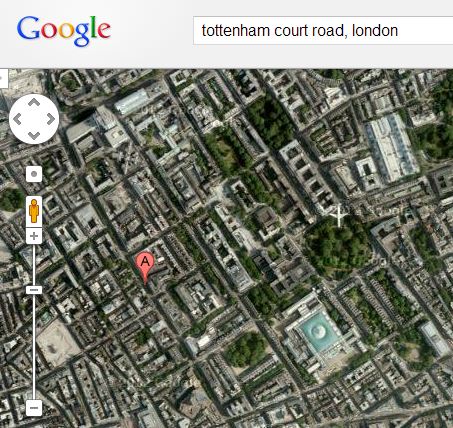
Do you see it, just north of the British Museum in the northern corner of Russell Square? Look closely, or click for a full-size capture:
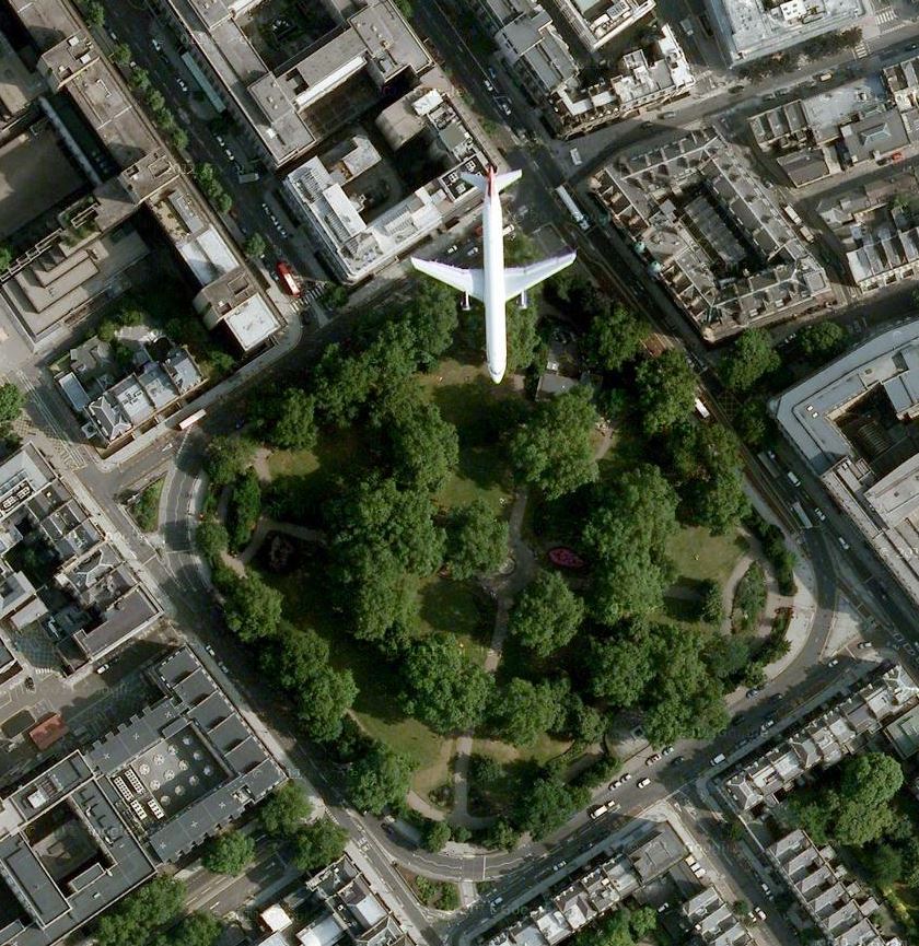
Looks like an A320, doesn't it? Can't tell whose. I just hope that it's as high up as I think it is.
National Public Radio has created an interactive map that uses Google Maps and new satellite images Google obtained yesterday to show 10-meter images of the Oklahoma tornado's destruction:
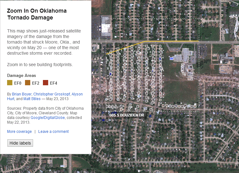
This may be the best, most timely use of geographic information in a news presentation I've ever seen.
The images are stunning. I can only imagine what life must be like in Moore right now—and with the NPR app, it's a lot easier to understand.
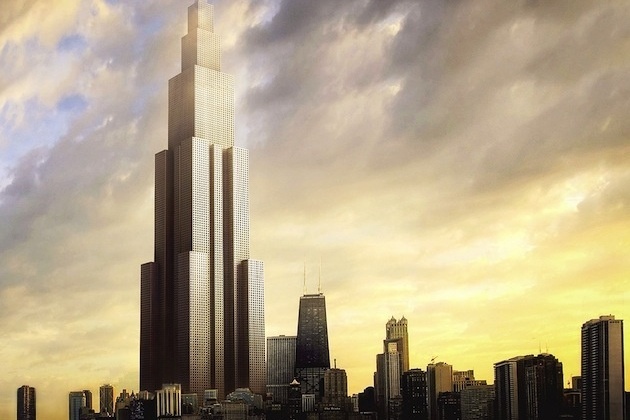
If you've ever played SimCity, you have probably encountered the Arcology, a massive self-contained building that houses thousands of people. They're almost here:
BSC is going to stuff 30,000 people into these self-contained skyscraper communities—a resident of Sky City will use up 1/100th of the land used by a typical Chinese citizen.
And it really is a city in and of itself—4,450 apartments, nearly 100,000 square feet of indoor vertical farms, 250 hotel rooms, 92 elevators, 30 foot courtyards for athletics, and a six mile ramp that can be used to walk or run around the entire city.
Once again, BSC intends to build this thing in seven months. How will that work? Treehugger's Lloyd Alter explains: "16,000 part-time and 3,000 full-time workers will prefabricate the building for four months and assemble on site in three months." (For a closer look at all of the design specs, see Alter's in-depth piece on the project.)
Imagine 7,000 apartments between 50 m² and 225 m² in size (as one variation calls for), and you've got either a really cool vertical city or Cabrini-Green to the third power.
When complete, the first one will be 828 m tall—10 m taller than the Burj Khalifa, but presumably better integrated with local water treatment and the local real estate market.
If they built it in Streeterville, it would look this scary:
I do not know whether this is a welcome idea or a truly horrifying one.
(Via Sullivan, of course.)
If you're a geography nerd, whatever you do, don't try playing Geoguessr. It will take hours of your life away.
The idea: it puts you down at a random spot on Google Street View, and you have to figure out where you are. Here's one of my attempts, before I realized I needed to do some work today.
I blame Randall Munroe.