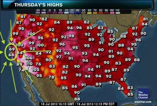
Chicago has experienced its first big heat wave of the year, with temperatures above 32°C every day this week. Yesterday, 46 of the lower 48 states reported temperatures in that range, with only North Dakota and Minnesota spared.
A friend who lives in San Francisco posted this with the caption, "Summer hits the Bay Area:"
It cooled down last night, so it's now just about
26°C...here. Only I'm going to New York in a few hours, where today will not only get to
35°C, but will have violent thunderstorms and buckets of rain. Good weekend to visit.
Here's the semi-annual
Chicago sunrise chart.
(You can get one for your own location at
http://www.wx-now.com/Sunrise/SunriseChart.aspx.)
|
Date
|
Significance
|
Sunrise
|
Sunset
|
Daylight
|
|
2013
|
|
2 Jul
|
8:30pm sunset
|
05:20
|
20:30
|
15:09
|
|
16 Jul
|
5:30am sunrise
|
05:30
|
20:24
|
14:53
|
|
9 Aug
|
8pm sunset
|
05:53
|
19:59
|
14:06
|
|
16 Aug
|
6am sunrise
|
06:00
|
19:49
|
13:49
|
|
29 Aug
|
7:30pm sunset
|
06:14
|
19:29
|
13:15
|
|
14 Sep
|
6:30am sunrise
|
06:30
|
19:02
|
12:31
|
|
15 Sep
|
7pm sunset
|
06:31
|
19:00
|
12:28
|
|
22 Sep
|
Equinox,
15:44 CDT
|
06:39
|
18:48
|
12:09
|
|
25 Sep
|
12-hour day
|
06:42
|
18:43
|
12:00
|
|
2 Oct
|
6:30pm sunset
|
06:50
|
18:30
|
11:41
|
|
12 Oct
|
7am sunrise
|
07:00
|
18:14
|
11:13
|
|
21 Oct
|
6pm sunset
|
07:11
|
18:00
|
10:49
|
|
2 Nov
|
Latest sunrise until 2 Nov 2016
Latest sunset until Mar 3rd
|
07:25
|
17:44
|
10:18
|
|
3 Nov
|
Standard time returns
Earliest sunrise until Mar 1st
|
06:26
|
16:42
|
10:16
|
|
6 Nov
|
6:30 sunrise
|
06:30
|
16:39
|
10:09
|
|
15 Nov
|
4:30pm sunset
|
06:41
|
16:30
|
9:48
|
|
2 Dec
|
7am sunrise
|
07:00
|
16:21
|
9:20
|
|
8 Dec
|
Earliest sunset of the year
|
07:06
|
16:20
|
9:13
|
|
21 Dec
|
Solstice,
11:11 CST
|
07:15
|
16:23
|
9:07
|
|
2014
|
|
3 Jan
|
Latest sunrise until Oct 29th
|
07:19
|
16:33
|
9:13
|
|
27 Jan
|
5pm sunset
|
07:08
|
17:00
|
9:51
|
|
4 Feb
|
7am sunrise
|
07:00
|
17:10
|
10:10
|
|
20 Feb
|
5:30pm sunset
|
06:40
|
17:30
|
10:50
|
|
27 Feb
|
6:30am sunrise
|
06:29
|
17:39
|
11:10
|
|
8 Mar
|
Earliest sunrise until Apr 13th
Earliest sunset until Oct 29th
|
06:15
|
17:50
|
11:35
|
|
9 Mar
|
Daylight savings time begins
Latest sunrise until Oct 24th
Earliest sunset until Sep 21st
|
07:13
|
18:51
|
11:38
|
|
17 Mar
|
7am sunrise, 7pm sunset
12-hour day
|
06:59
|
19:00
|
12:00
|
|
20 Mar
|
Equinox
11:57 CDT
|
06:54
|
19:03
|
12:09
|
|
3 Apr
|
6:30am sunrise (again)
|
06:30
|
19:19
|
12:48
|
|
13 Apr
|
7:30pm sunset
|
06:13
|
19:30
|
13:16
|
|
22 Apr
|
6am sunrise
|
06:00
|
19:39
|
13:39
|
|
11 May
|
8pm sunset
|
05:35
|
20:00
|
14:25
|
|
16 May
|
5:30am sunrise
|
05:30
|
20:06
|
14:36
|
|
14 Jun
|
Earliest sunrise of the year
|
05:15
|
20:28
|
15:12
|
|
20 Jun
|
Solstice
18:09 CDT
8:30pm sunset
|
05:16
|
20:30
|
15:14
|
|
27 Jun
|
Latest sunset of the year
|
05:18
|
20:31
|
15:12
|
You can get sunrise information
for your location at wx-now.com.
As predicted yesterday, Chicago has had more rain so far this year than we had all last year—699 mm in the first half of 2013 v. 684 mm in all of 2012.
That also makes the first half of 2013 the wettest January to June ever:
Wednesday morning’s deluge is just the latest to hit portions of the Greater Chicago area in a year which has been producing precipitation at a record rate. There hasn’t been a single year since official weather records began 142 years ago in 1871 which has produced a year-to-date precipitation tally greater than the 699 mm currently on the books.
Meanwhile, in the West:
Forecasters in the West aren’t mincing words about the heat preparing to intensity before the week’s end across that region. They are referring to the impending heat wave as one of "potentially historic and prolonged proportions."
Excessive heat warnings have been issued from Arizona into southern California and a swath of Utah and Colorado with temperatures in Phoenix predicted to reach the 45-48°C range while Las Vegas heats toward 47°C and the hottest readings near Death Valley move to within striking distance of 54°C.
Next weekend I'll be in parts of the country much cooler than Phoenix (in so many ways).
Note: The DOMA and Prop 8 decisions just came out during the phone meeting that interrupted this entry. I'm sure I'll have something to say about SCOTUS in a few hours. Right now, I have to take advantage of the letup in rain and get to the office.
We now return you to your regularly-scheduled blog entry, already in progress:
The monsoon-like rains stalled over the Chicago area today, which will push us past having more precipitation in six months (662 mm as of 7am, with the rain still coming down) than we had all last year (684 mm), isn't the only bit of weather this week enhanced by anthropogenic climate change. Yesterday it was hotter in Alaska than it's been in Chicago since last summer:
Alaskans dealing with unusual heat; Fairbanks' 33.3°C Tuesday high exceeds Chicago’s 2013 peak to-date of 32.7°C to date.
It was snow and an abnormally chilly late spring temp regime which headlined Alaska weather only a little over a month ago. Since then, an extraordinarily rapid transition to record heat has followed—a warm-up which has generated some of the state's warmest temperatures on the books.
The 33.3°C high recorded Tuesday at Fairbanks is warmer than any daytime high recorded yet this year in Chicago. And 90s [Fahrenheit]—in some cases mid-90s [Fahrenheit]—were common in Interior Alaska Tuesday with some 90-degree temps recorded in Canada’s adjacent Yukon Territory as well.
In fact, the heat in central Alaska may accelerate climate change, since melting tundra releases methane gas into the atmosphere. Fun times, fun times.
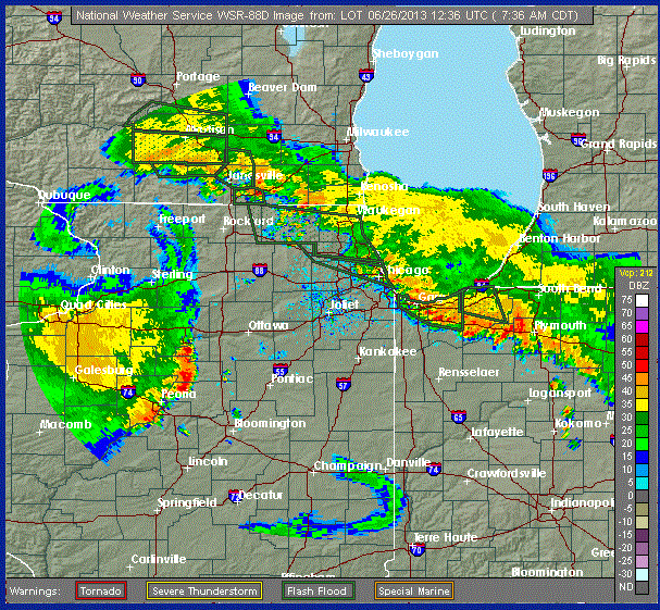
We've got a bit of rain in Chicago this morning:
UPDATE: 7:00 am
Arlington Heights 93 mm
Mundelein 65 mm of rain
Wheeling Chicago Executive airport 107 mm between 4-7am
Lake Zurich 135 mm
McHenry 134 mm- Most of it falling since 3am
Crystal Lake 24 hour rainfall 114 mm
The rain has shut down area transportation:
Flooding has closed the Edens Expressway at Pratt Avenue this morning and has stopped at least three trains on Metra's Union Pacific Northwest Line.
The expressway was closed around 7 a.m., according to the Illinois State Police. Officers were diverting northbound traffic at Peterson Avenue and southbound traffic at Touhy Avenue.
Here's the one-hour rainfall total from the National Weather Service:
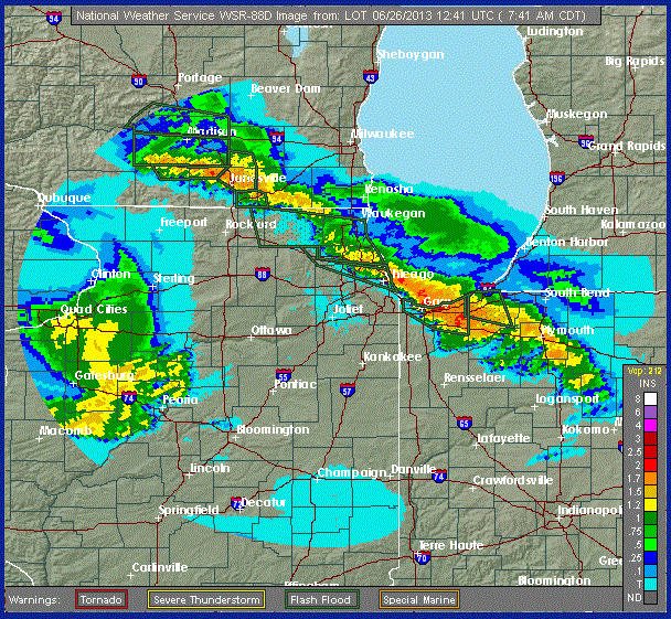
And the current image, showing a line of storms stalled across the region:
I'm debating going into the office...
The twister—as much as a 4200-meter-wide monster can twist—that hit Oklahoma last week broke all kinds of records:
In the rare category of EF5 tornadoes, the one on Friday in the El Reno area was “super rare,” a National Weather Service meteorologist said Tuesday.
The Weather Service updated its estimate Tuesday of the tornado that struck El Reno Friday, determining it was an EF5, the strongest classification for a twister. It was a record 4.2 km wide and tracked across 26 km.
During Friday's storm, the University of Oklahoma RaXPol — a rapid-scan, polarimetric mobile Doppler radar — measured winds greater than 475 km/h at several times and locations within 150 m of the ground along the south side of subvortices on the south side of the tornado.
Fortunately (there's an understatement), the tornado struck a rural area some distance from Oklahoma City, and no one got seriously hurt
But...wow. That's one hell of a storm.
National Public Radio has created an interactive map that uses Google Maps and new satellite images Google obtained yesterday to show 10-meter images of the Oklahoma tornado's destruction:
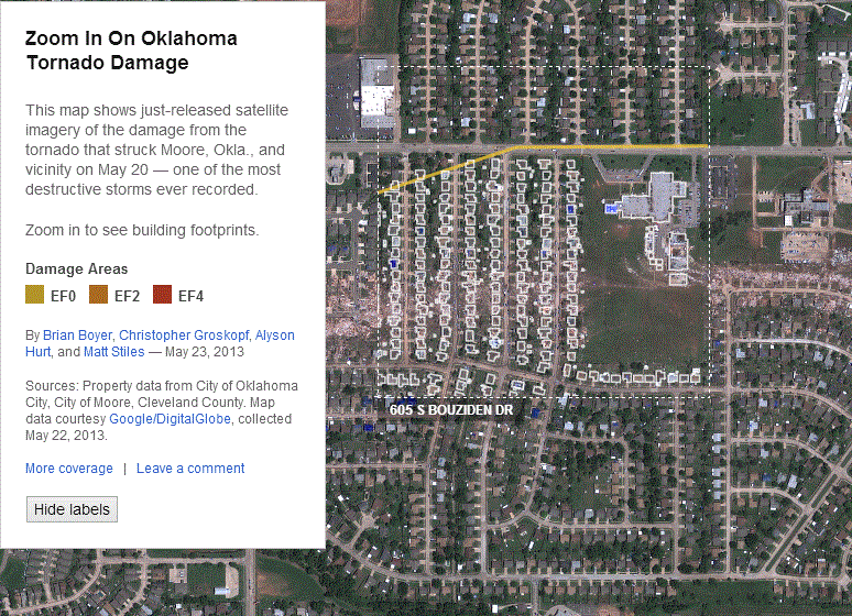
This may be the best, most timely use of geographic information in a news presentation I've ever seen.
The images are stunning. I can only imagine what life must be like in Moore right now—and with the NPR app, it's a lot easier to understand.
It's 26°C and sunny in Chicago right now, so I'm going for yet another walk. Regular posting to resume later today or tomorrow.
Less than two weeks ago, southern Minnesota had 25 cm of snow on the ground. Yesterday, the region hit 40°C following the biggest two-day temperature swing in decades:
Even more dramatic were the stunning weather changes which occurred to Chicago's west Tuesday. Soaring temperatures smashed records from Nebraska into western Iowa, Minnesota and western Wisconsin—areas which less than 2 weeks earlier had been crippled by a record-breaking foot or more of late-season snow.
Albert Lea, Minnesota recorded a 38°C high Tuesday. Only 12 days earlier that city had been buried under a 250 mm accumulation of snow.
Iowa's state climatologist Harry Hillaker reported in a special weather statement out of the National Weather Service Forecast Office in Des Moines Tuesday that 38°C or higher temperatures have occurred in the month of May on only 11 occasions since official weather records began in the state in 1873. Even rarer have been 38°C readings two weeks after a major snowstorm. Hillaker reports this has happened only a few times over that period.
Here in Chicago, O'Hare hit 33°C and Midway hit 32°C, while at Inner Drive Technology World Headquarters—800 m from Lake Michigan—the temperature hovered around 21°C until the sun went down. Without the sun heating the city, the lake breeze stopped, and temperatures rose. Sitting at Wrigley Field last night, I had my sweater on in the first two innings and was down to a T-shirt by the 6th.
Today's forecast calls for rapidly dropping temperatures bottoming out around 14°C by 4pm.
Welcome to 400 ppm CO2, folks. With more energy in the atmosphere, continental climates like the Midwest U.S. will have these violent temperature changes pretty normally from now on.
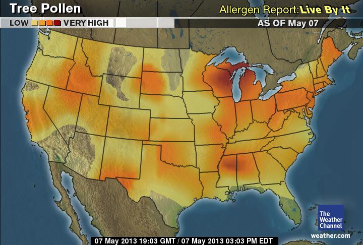
Pollen levels in Chicago have exploded in the past week:
The area’s pollen values surged Tuesday to the highest levels of the year, the latest development in a allergy season which has brought misery to many across the Chicago area. Dr. Joseph Leija, allergist at Loyola Gottlieb Memorial Hospital and provider of this area’s pollen counts, lamented in his daily report that the slow pace of spring warming has combined with the season’s huge rain tallies to bring high tree counts at the same time high grass and weed levels are present. The result, says Dr. Leija, has been to make allergy sufferers miserable despite the lovely weather of late. Swollen and itchy eyes were among the reasons many patients visited his office as well as the need for medication adjustments
Tree, grass and weed pollen were ALL reported as “high” Tuesday. Tree pollen reached 1,000 grains per cubic yard—just 500 below the “alert level” of 1,500.
This is just tree pollen; the mold, grass, and ragweed maps have pretty colors over Illinois also:
I've been sneezing and coughing for three days now. I'm really looking forward to the plants finishing up their orgy of...well, orgies.