Yesterday my trip to work was cold and wet, while on the West Coast it was so warm people in San Francisco were trying to remember if their apartments had air conditioning. (They don't.)
Well, it's no longer quite as hot in San Francisco, but here in Chicago it's still cold and wet: 4°C and—wait, you'll love this—snow.
That's right, past the mid-point of May and only two weeks from the start of meteorological summer, it snowed in Chicago.
Last night the temperature here got down to 5°C, which feels more like early March than mid-May. Meanwhile, in San Francisco, yesterday got up to 33°C, which to them feels like the pit of hell. In fact, even in the hottest part of the year (early October), San Francisco rarely gets that warm. The Tribune explains:
The North American jet stream pattern, a key driver of the country’s weather, has taken on the same incredibly “wavy”—or, as meteorologists say —“meridional”—configuration which has so often dominated the winter and spring. This sort of pattern leads to temperature extremes across the content.
Pools of unseasonably warm air are in place on each coast while unseasonably cool air is sandwiched between and dominates Chicago and Midwestern weather.
It’s within this slow-moving pool of chilly, unstable (i.e. cloud and precip-generating) air that Chicago resides—a situation likely to continue into Saturday. This is to keep extensive cloudiness and the potential for sporadic showers going over that period of time.
In other words, the forecast for this weekend is continued March with a possibility of April by Monday.
Ten days until I get a couple days off...
The Chicago Tribune has an infographic this weekend with the final statistics of the past winter. After defining the "cold season" as the "period from the first freeze of the fall to the last freeze of spring," and asserting we've had our last freeze (I'll let that float for now), then the 2013-14 winter looked like this:
| Measurement |
Value |
|
First freeze
|
Oct 22nd (-2°C)
|
|
Last freeze
|
Apr 16th (-4°C)
|
|
Days below freezing
|
76 (Nov through Mar)
|
|
Days below -18°C
|
26 (Dec through Mar)
|
|
Total snowfall
|
2,082 mm
|
It would have been helpful, I think, had they included some comparison data. It still encapsulates a really crappy winter, which now, finally, seems over.
At 1pm, the official temperature at O'Hare was 28°C. It has not been this warm in Chicago since November 7th, six months ago. The last time we had weather warmer than that was September 28th (29°C).
Good thing I'm inside...working...
Update: The official 2pm temperature of 30°C has not occurred in Chicago since September 11th, 239 days ago.
I almost forgot, even though Illinois Climatologist Jim Angel blogged it earlier today. The new NCA is here. Highlights—with a distinctly Illinois-centered view—via Angel:
- In the next few decades, longer growing seasons and rising carbon dioxide levels will increase yields of some crops, though those benefits will be progressively offset by extreme weather events. Though adaptation options can reduce some of the detrimental effects, in the long term, the combined stresses associated with climate change are expected to decrease agricultural productivity.
- Increased heat wave intensity and frequency, increased humidity, degraded air quality, and reduced water quality will increase public health risks.
- Climate change will exacerbate a range of risks to the Great Lakes, including changes in the range and distribution of certain fish species, increased invasive species and harmful blooms of algae, and declining beach health. Ice cover declines will lengthen the commercial navigation season [this winter was the exception to the rule - Jim].
If you don't mind using 170 megabytes of bandwidth, you can download the whole thing (or just the parts you want).
Actually, it's a live feed from the ISS:
Live streaming video by Ustream
IFLS explains:
One of the latest missions from the ISS is kind of amazing. The High Definition Earth Viewing (HDEV) experiment consists of four cameras that have been attached outside of the ISS. Though temperature is controlled, the cameras are exposed to the radiation from the sun, which will allow astronauts to understand how radiation affects the instruments.
The cameras point down at Earth at all times, which makes for some breathtaking images. The feed will sometimes go down as the signal switches between the cameras, and it is hard to see when the ISS is on the dark side of the planet. If the cameras are down, the screen will be grey.
As I'm posting this, the ISS was just past the morning terminator, near the Philippines. It should fly almost directly over Chicago in 20 minutes or so. (The ISS orbits once every 92 minutes.)
Via WGN's weather blog, here is the coolest climate visualizer I've seen:
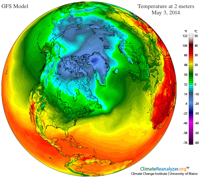
The site also has forecast maps and animation, climate information, and (of course) a blog.
The Scripps Institution of Oceanography at UCSD reported this week that atmospheric carbon dioxide averaged more than 400 ppm in April, a new milestone:
Every single daily carbon dioxide measurement in April 2014 was above 400 parts per million. That hasn’t happened in nearly a million years, and perhaps much longer. Climate scientists have proven that the rise in human-produced greenhouse gases like carbon dioxide are “extremely likely” to be the dominant cause of global climate change. The likelihood of dangerous impacts—like sea level rise, hotter heat waves, and certain types of extreme weather—increases with each incremental annual rise in atmospheric carbon dioxide.
Carbon dioxide levels have increased by more than 40 percent since humans first started burning fossil fuels in large quantities about 250 years ago. Once released, the carbon dioxide from coal, oil, and natural gas burning can remain in the atmosphere for centuries. Thus, the crux of the problem: There just hasn’t been enough time yet since those first coal-powered factories in Europe for the atmosphere to return to equilibrium. What’s more, the pace of fossil fuel burning has since dramatically quickened—there’ve been more greenhouse gas emissions in the last 40 years than over the previous 200—so carbon dioxide buildup keeps accelerating.
So what about the hockey stick? If you look at the last 800,000 years, the chart of CO2 concentration looks more like a brick wall:

Scary.
Today is May Day, but it feels like mid-March. Instead of the normal 18°C for May 1st, we're going to get, if we're lukcy, 9°C, with some gray skies and drizzle to drive the point home.
The WGN Weather Center has more:
A sprinkly, damp chill hung over Chicago as April 2014 closed overnight. The month finished 0.2°C below normal—a fraction of the deficit that’s been recorded in a number of recent months.
The shortfall, small as it is, means April goes down in the record books here as the 6th consecutive month with an average temperature cooler than normal.
The 12°C high with which the month closed Wednesday was coolest final day of April in 18 years. That reading was, in marked contrast, a full 18°C cooler than the 29°C high recorded on April 30th a year ago.
Chicago’s cloud cover has been extensive over all four days that the area’s weather pattern has been under the influence of the most recent mammoth spring storm. Sunshine during that period has amounted to a paltry 16%–less than a third normal. Historically, Aprils have produced 52% of their possible sun.
One of the coldest winters in history has given way to one of the dreariest springs in recent memory. No wonder so many people want to leave Illinois.
At least it should be warmer next week.